The Skippers Pluton

NaturalSkippersOutcrop

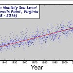
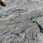
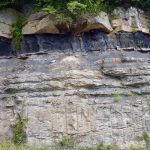
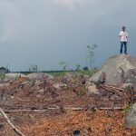
Finding bedrock outcrop in the Piedmont of Southside Virginia can be challenging.  Much of the terrain is covered by soil and saprolite, and geologists interested in this region must search high and low for outcrop.  The image above illustrates a ‘good’ natural outcrop in the Piedmont, likely the result of a relatively resistant rock that […]

Sea Level Change at Sewells Point

SewellsMeanMonthlySeaLevel

The level of the sea has been measured at Sewells Point, Virginia continuously since 1928.  In 1928 the mean level of the sea was ~45 cm ( ~18″) lower than it is in 2016.  Sea level rise and regional land subsidence is creating an ever-growing problem in Hampton Roads and most of coastal Virginia.

Chopawamsic Gneiss

ChopGarbenSch

This exposure in a pasture near Cuckoo exposes a poly-deformed hornblende and plagioclase-rich gneiss. Foliation in the gneiss has been refolded.  Another interesting feature is the presence of garbenschiefer or “feather amphibolite.” This unusual texture is defined by stellate and featherlike hornblende clusters in the plane of foliation. Three amphibole species occur in this rock […]

The Appalachian Plateau’s rugged terrain

APlateauDEM

In Virginia the Appalachian Plateau province is not particularly ‘plateau-like’, rather the region is characterized by rugged topography and steep slopes.  It is a well-dissected upland, and streams draining the region have a classic dendritic drainage pattern.  The featured image of Buchanan County (and the surrounding areas of Kentucky and West Virginia) is a shaded relief map […]

Boudins or Pillows?

Surface of quarried block in the Catoctin Formation.

This is going to be trouble…

The Defenses of Yorktown

YorktownDefenseThumbnail

Yorktown became a famous locale in 1781 after the surrender of the British troops which effectively ended the Revolutionary War.  British forces in and around Yorktown dug a number of defensive earthworks that were sieged by American and French troops over a three-week period prior to the surrender on October 19th, 1781. In the early 21st […]

Coal Strata in the Appalachian Plateau

Layers of sandstone, shale, and coal in the Appalachian Plateau, Wise County.

The Cumberland Gap

ThumbnailCumberland

Cumberland Gap, elevation 506 m (1,660′), in the far southwestern corner of Virginia is a wind gap near the geographic triple point* between Virginia, Tennessee, and Kentucky. The gap has long been an important crossing point through the Appalachian Mountains, and lies at the western edge of the Valley & Ridge province with the Appalachian Plateau province […]

Dunes at False Cape State Park

Dunes at False Cape State Park in Virginia Beach.  Dunes are common features along the Virginia coast.

Dunes are common landforms along Virginia’s sandy coast and its barrier islands.

Twenty years of change at Cedar Island

Thumbnail

Cedar Island is one of Virginia’s barrier islands that separates the Eastern Shore from the Atlantic Ocean. Barrier islands are dynamic environments that respond quickly to environmental changes. Over time barrier islands move, and their shorelines migrate. During the past two decades shoreline change at the south end of Cedar Island has been dramatic. Compare the 1994 […]