A Resource for Information on the Commonwealth's Geology
Featured Image
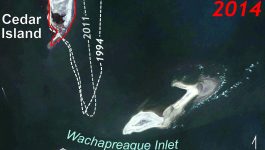
Twenty years of change at Cedar Island
Cedar Island is one of Virginia’s barrier islands that separates the Eastern Shore from the Atlantic Ocean. Barrier islands are dynamic environments that respond quickly to environmental changes. Over time barrier islands move, and their shorelines migrate. During the past two decades shoreline change at the south end of Cedar Island has been dramatic. Compare the 1994 […]
What’s New in Virginia Geology
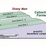
Virginia is for Lavas- The Catoctin Formation
Many of the highest peaks in Shenandoah National Park (including Hawksbill, Stony Man, and Hightop Mountain, just to name a few) are underlain by distinctive bluish-green rocks that were once ancient lava flows (Virginia is for Lavas!), and are part of a geologic unit known as the Catoctin Formation. From the presidential retreat at Camp David to Jefferson’s […]