A Resource for Information on the Commonwealth's Geology
Featured Image

The Cumberland Gap
Cumberland Gap, elevation 506 m (1,660′), in the far southwestern corner of Virginia is a wind gap near the geographic triple point* between Virginia, Tennessee, and Kentucky. The gap has long been an important crossing point through the Appalachian Mountains, and lies at the western edge of the Valley & Ridge province with the Appalachian Plateau province […]
What’s New in Virginia Geology
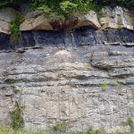
At the Pluton’s Edge
When large quantities of magma intrude and solidify in the Earth’s crust they form bodies of intrusive igneous rock known as plutons. The featured image nicely illustrates the edge (geologic contact) of a granitic pluton in the Blue Ridge Mountains of central Virginia. The granite is part of the 706 ± 4 million year old […]