Highland County Geologic Map

HighlandGeoMap

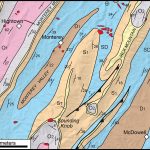
This image illustrates part of the geological map of Highland County, Virginia in the Valley & Ridge province.  Note the linear belts Paleozoic sedimentary rocks that are repeated by folding.  From oldest to youngest these include O1 = lower Ordovician strata, O2 = upper Ordovician strata, S1 = Silurian strata, SD = Silurian-Devonian strata, D1 […]

Micrograph of Deformed Quartz Sandstone

Print

This micrograph colorfully illustrates deformed quartz grains in a well-cemented quartz sandstone from the Cambrian Antietam Formation, a prominent geologic unit in the Blue Ridge geologic province.  Many of the individual sand grains are elongated (~horizontal orientation), but not recrystallized.  Photo taken in cross polarized light with the gypsum plate inserted.

Hylas Zone Mylonite

HylasZoneMylonite

This micrograph illustrates a mylonite from the Hylas Zone in the eastern Piedmont ~5 km west of Doswell, Virginia.  The rock is characterized by a well-developed foliation with elongate quartz ribbons (transparent grains) and feldspar porphyroclasts.  The rock originally was a granodiorite that was strongly deformed and sheared, under ductile conditions, into a mylonite. Checkout […]

Mouth of the Rappahannock River

Aerial view (to the southeast) towards the mouth of the Rappahannock River

The Rappahannock River forms a broad estuary as it flows to towards the Chesapeake Bay in Virginia’s Coastal Plain province. To the south the Piankatank River is also visible.  The Rappahannock and Piankatank rivers are tidal estuaries.

Cliffs of Westmoreland

WestmorelandCliff

The Cliffs of Westmoreland rise 30 to 45 meters (~100 to 150′) above the waters of the Potomac River.  These bluffs expose Miocene to Pliocene sedimentary units, some which are quite fossiliferous.  For more information on the geology of Westmoreland checkout the 2005 Virginia Geological Field Conference guidebook by Buck Ward and others. Note the […]

Nottoway Falls

Nottoway Falls in the Piedmont of south-central Virginia

Nottoway Falls is an impressive set of cascades along the Nottoway River in the south-central Piedmont.  Here the Nottoway River forms an impressive knick zone, dropping ~30 meters (~100′) in less than 1 kilometer (0.6 mi.).  A strongly lineated granitic gneiss is well-exposed during low water conditions.  The origin of this knick zone is poorly […]

Virginia’s State Fossil

Chesapectean Fossil

This distinctive scallop is the state fossil of Virginia and is the first fossil described from North America in 1687. Chesapecten sp. are commonly found in strata exposed along Coastal Plain cliffs along major rivers in southeastern Virginia and eastern North Carolina. Chesapecten jeffersonius is the index fossil for the Lower Yorktown Formation, and is distinguished by the number […]

Old Rag Mountain

The NW face of Old Rag Mountain, which is situated in the Shenandoah National Park. This mountain is famous for the rock scramble that is at the top.

Old Rag Mountain is nestled in the Blue Ridge Mountains in Shenandoah National Park. The trail leading to the top is one of the most popular hikes in Virginia. This is due to the fantastic views, and the scrambling nature of the hike required to reach the summit.  The large granitic boulders provide a unique rock […]

Mount Rogers

Mt Rogers

Mount Rogers is the highest peak in Virginia, with its summit 1,746 meters above sea level (5,729 ft). The peak is located in the Blue Ridge province in southwestern Virginia on the border between Grayson and Smyth counties.  Mount Rogers is underlain by Neoproterozoic rhyolite.  The upper reaches of the mountain are cloaked in alpine forests of red […]

Fault Breccia in the Blue Ridge

Photomicrograph of fault breccia in the Antietam Formation, Blue Ridge province. Breccias form when rocks are extensively fractured in fault zones and are cemented together when minerals precipitate in the cracks and fractures. Note the angular fragments (fr) of quartz sandstone in a matrix of fine-grained iron oxide cement (ic). Field of View 4 x 2.7 mm, Cross Polarized Light.

Photomicrograph of fault breccia in the Cambrian Antietam Formation, Blue Ridge province. Breccias form when rocks are extensively fractured in fault zones and are cemented together when minerals precipitate in the cracks and fractures. Note the angular fragments (fr) of quartz sandstone in a matrix of fine-grained iron oxide cement (ic). Field of view 4 […]