Virginia is for Lavas- The Catoctin Formation
August 3, 2016 by ·
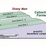
Many of the highest peaks in Shenandoah National Park (including Hawksbill, Stony Man, and Hightop Mountain, just to name a few) are underlain by distinctive bluish-green rocks that were once ancient lava flows (Virginia is for Lavas!), and are part of a geologic unit known as the Catoctin Formation. From the presidential retreat at Camp David to Jefferson’s […]
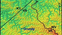
Highland County Geologic Map
August 2, 2016 by ·
This image illustrates part of the geological map of Highland County, Virginia in the Valley & Ridge province. Note the linear belts Paleozoic sedimentary rocks that are repeated by folding. From oldest to youngest these include O1 = lower Ordovician strata, O2 = upper Ordovician strata, S1 = Silurian strata, SD = Silurian-Devonian strata, D1 […]
Micrograph of Deformed Quartz Sandstone
August 2, 2016 by ·
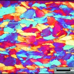
This micrograph colorfully illustrates deformed quartz grains in a well-cemented quartz sandstone from the Cambrian Antietam Formation, a prominent geologic unit in the Blue Ridge geologic province. Many of the individual sand grains are elongated (~horizontal orientation), but not recrystallized. Photo taken in cross polarized light with the gypsum plate inserted.
Hylas Zone Mylonite
August 2, 2016 by ·
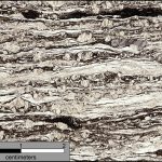
This micrograph illustrates a mylonite from the Hylas Zone in the eastern Piedmont ~5 km west of Doswell, Virginia. The rock is characterized by a well-developed foliation with elongate quartz ribbons (transparent grains) and feldspar porphyroclasts. The rock originally was a granodiorite that was strongly deformed and sheared, under ductile conditions, into a mylonite. Checkout […]
Mouth of the Rappahannock River
August 1, 2016 by ·
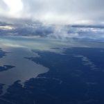
The Rappahannock River forms a broad estuary as it flows to towards the Chesapeake Bay in Virginia’s Coastal Plain province. To the south the Piankatank River is also visible. The Rappahannock and Piankatank rivers are tidal estuaries.
Cliffs of Westmoreland
August 1, 2016 by ·
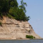
The Cliffs of Westmoreland rise 30 to 45 meters (~100 to 150′) above the waters of the Potomac River. These bluffs expose Miocene to Pliocene sedimentary units, some which are quite fossiliferous. For more information on the geology of Westmoreland checkout the 2005 Virginia Geological Field Conference guidebook by Buck Ward and others. Note the […]
Nottoway Falls
August 1, 2016 by ·
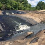
Nottoway Falls is an impressive set of cascades along the Nottoway River in the south-central Piedmont. Here the Nottoway River forms an impressive knick zone, dropping ~30 meters (~100′) in less than 1 kilometer (0.6 mi.). A strongly lineated granitic gneiss is well-exposed during low water conditions. The origin of this knick zone is poorly […]
Virginia’s State Rock: Nelsonite
August 1, 2016 by ·
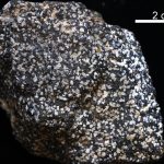
On July 1, 2016, Governor Terry McCauliffe signed a bill into law that made nelsonite the first official state rock of Virginia. The initiative for this project was led by students from Piedmont Virginia Community College. Michelle Stanislaus and her classmates from their Historical Geology class and Government class ran the petition for this law starting […]