Micrograph of Deformed Quartz Sandstone

Print

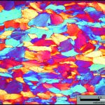
This micrograph colorfully illustrates deformed quartz grains in a well-cemented quartz sandstone from the Cambrian Antietam Formation, a prominent geologic unit in the Blue Ridge geologic province.  Many of the individual sand grains are elongated (~horizontal orientation), but not recrystallized.  Photo taken in cross polarized light with the gypsum plate inserted.

Mount Rogers

Mt Rogers

Mount Rogers is the highest peak in Virginia, with its summit 1,746 meters above sea level (5,729 ft). The peak is located in the Blue Ridge province in southwestern Virginia on the border between Grayson and Smyth counties.  Mount Rogers is underlain by Neoproterozoic rhyolite.  The upper reaches of the mountain are cloaked in alpine forests of red […]

Fault Breccia in the Blue Ridge

Photomicrograph of fault breccia in the Antietam Formation, Blue Ridge province. Breccias form when rocks are extensively fractured in fault zones and are cemented together when minerals precipitate in the cracks and fractures. Note the angular fragments (fr) of quartz sandstone in a matrix of fine-grained iron oxide cement (ic). Field of View 4 x 2.7 mm, Cross Polarized Light.

Photomicrograph of fault breccia in the Cambrian Antietam Formation, Blue Ridge province. Breccias form when rocks are extensively fractured in fault zones and are cemented together when minerals precipitate in the cracks and fractures. Note the angular fragments (fr) of quartz sandstone in a matrix of fine-grained iron oxide cement (ic). Field of view 4 […]