A Resource for Information on the Commonwealth's Geology
Featured Image
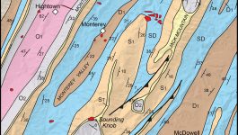
Highland County Geologic Map
This image illustrates part of the geological map of Highland County, Virginia in the Valley & Ridge province. Note the linear belts Paleozoic sedimentary rocks that are repeated by folding. From oldest to youngest these include O1 = lower Ordovician strata, O2 = upper Ordovician strata, S1 = Silurian strata, SD = Silurian-Devonian strata, D1 […]
What’s New in Virginia Geology
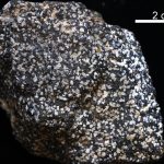
Virginia’s State Rock: Nelsonite
On July 1, 2016, Governor Terry McCauliffe signed a bill into law that made nelsonite the first official state rock of Virginia. The initiative for this project was led by students from Piedmont Virginia Community College. Michelle Stanislaus and her classmates from their Historical Geology class and Government class ran the petition for this law starting […]