A Resource for Information on the Commonwealth's Geology
Featured Image
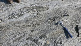
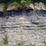
Chopawamsic Gneiss
This exposure in a pasture near Cuckoo exposes a poly-deformed hornblende and plagioclase-rich gneiss. Foliation in the gneiss has been refolded. Another interesting feature is the presence of garbenschiefer or “feather amphibolite.” This unusual texture is defined by stellate and featherlike hornblende clusters in the plane of foliation. Three amphibole species occur in this rock […]
What’s New in Virginia Geology
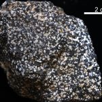
Virginia’s State Rock: Nelsonite
On July 1, 2016, Governor Terry McCauliffe signed a bill into law that made nelsonite the first official state rock of Virginia. The initiative for this project was led by students from Piedmont Virginia Community College. Michelle Stanislaus and her classmates from their Historical Geology class and Government class ran the petition for this law starting […]