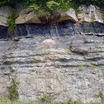
A Resource for Information on the Commonwealth's Geology
Featured Image
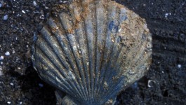
Virginia’s State Fossil
This distinctive scallop is the state fossil of Virginia and is the first fossil described from North America in 1687. Chesapecten sp. are commonly found in strata exposed along Coastal Plain cliffs along major rivers in southeastern Virginia and eastern North Carolina. Chesapecten jeffersonius is the index fossil for the Lower Yorktown Formation, and is distinguished by the number […]
What’s New in Virginia Geology
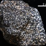
Virginia’s State Rock: Nelsonite
On July 1, 2016, Governor Terry McCauliffe signed a bill into law that made nelsonite the first official state rock of Virginia. The initiative for this project was led by students from Piedmont Virginia Community College. Michelle Stanislaus and her classmates from their Historical Geology class and Government class ran the petition for this law starting […]