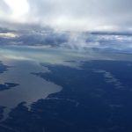
The Rappahannock River forms a broad estuary as it flows to towards the Chesapeake Bay in Virginia’s Coastal Plain province. To the south the Piankatank River is also visible. The Rappahannock and Piankatank rivers are tidal estuaries.
A Resource for Information on the Commonwealth's Geology
The Rappahannock River forms a broad estuary as it flows to towards the Chesapeake Bay in Virginia’s Coastal Plain province. To the south the Piankatank River is also visible. The Rappahannock and Piankatank rivers are tidal estuaries.
Mount Rogers is the highest peak in Virginia, with its summit 1,746 meters above sea level (5,729 ft). The peak is located in the Blue Ridge province in southwestern Virginia on the border between Grayson and Smyth counties. Mount Rogers is underlain by Neoproterozoic rhyolite. The upper reaches of the mountain are cloaked in alpine forests of red […]
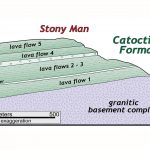
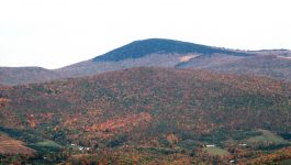
Many of the highest peaks in Shenandoah National Park (including Hawksbill, Stony Man, and Hightop Mountain, just to name a few) are underlain by distinctive bluish-green rocks that were once ancient lava flows (Virginia is for Lavas!), and are part of a geologic unit known as the Catoctin Formation. From the presidential retreat at Camp David to Jefferson’s […]