A Resource for Information on the Commonwealth's Geology
Featured Image
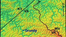
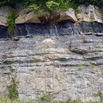
The Appalachian Plateau’s rugged terrain
In Virginia the Appalachian Plateau province is not particularly ‘plateau-like’, rather the region is characterized by rugged topography and steep slopes. It is a well-dissected upland, and streams draining the region have a classic dendritic drainage pattern. The featured image of Buchanan County (and the surrounding areas of Kentucky and West Virginia) is a shaded relief map […]
What’s New in Virginia Geology
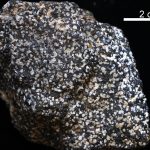
Virginia’s State Rock: Nelsonite
On July 1, 2016, Governor Terry McCauliffe signed a bill into law that made nelsonite the first official state rock of Virginia. The initiative for this project was led by students from Piedmont Virginia Community College. Michelle Stanislaus and her classmates from their Historical Geology class and Government class ran the petition for this law starting […]